Kōpuaranga
Kōpuaranga | |
|---|---|
Locality | |
| [mapframe not available on SimWiki] Interactive map of Kōpuaranga | |
| Coordinates: 40°50′S 175°40′E / 40.833°S 175.667°E | |
| Country | File:Flag of New Zealand.svg New Zealand |
| Region | Wellington Region |
| Territorial authority | Masterton District |
| Ward |
|
| Electorates | |
| Government | |
| • Territorial Authority | Masterton District Council |
| • Regional council | Greater Wellington Regional Council |
| • Mayor of Masterton | Bex Johnson[1] |
| • Wairarapa MP | Mike Butterick[2] |
| • Ikaroa-Rāwhiti MP | Cushla Tangaere-Manuel[3] |
| Area | |
• Total | 61.69 km2 (23.82 sq mi) |
| Population (2023 census)[5] | |
• Total | 171 |
| • Density | 2.77/km2 (7.18/sq mi) |

Kōpuaranga, until 1906 called Dreyerton, is a rural locality[6] in the Wairarapa region of New Zealand's North Island, between Masterton and Mauriceville.
Etymology
The name Kōpuaranga comes from Māori words meaning 'deep hole' and 'shoal of fish'.[7]
History
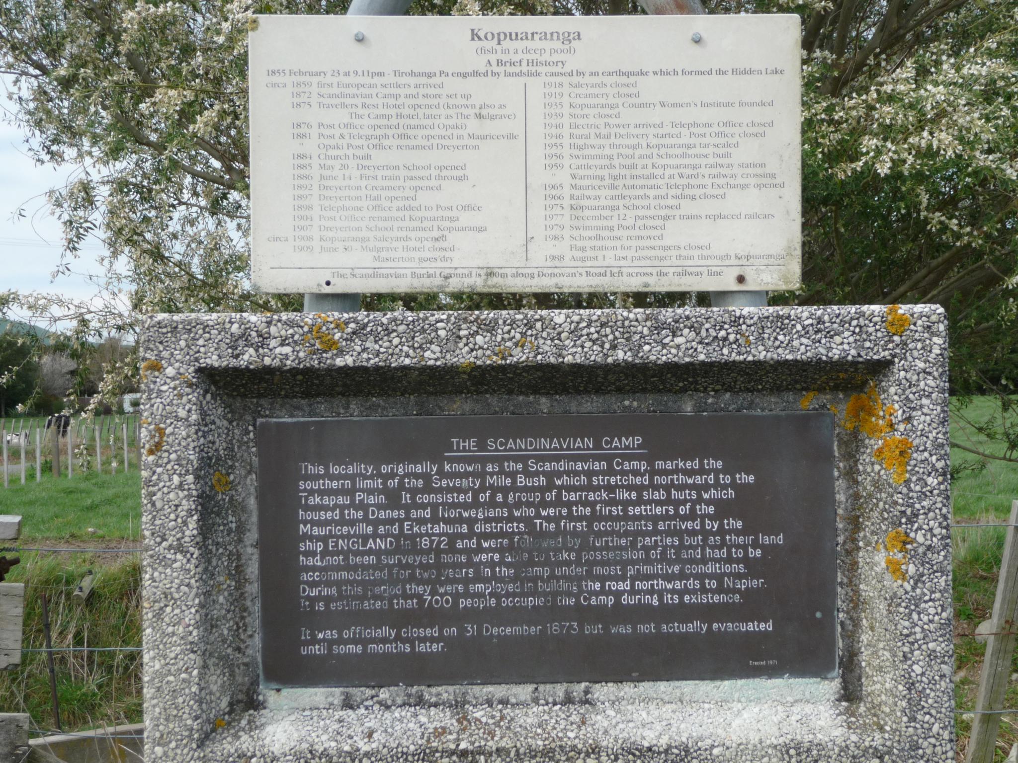
The area was a temporary camp used by Scandinavians who had been brought in to clear and settle the Seventy Mile Bush, but could not take up their allotted land until it had been surveyed, and the area was thus known simply as The Camp[7] or The Scandinavian Camp,[8] the camp was officially closed on 31 December 1873, and an estimated 700 people had occupied the camp during its existence.
In 1876 a Post Office was opened, named Opaki, however the settlement's name was changed to Dreyerton[9] in 1881,[8] after Danish interpreter Alexander Svend Dreyer,[9] who had accompanied the pioneers and conceived the idea for a township.[10]
Dreyerton school was founded in 1885, and in 1897 the school had an average attendance of about forty.[11] One amusing incident during the school's history was the school committee election of 1889, which fell through when only the committee members arrived, and refused to vote for themselves.[10] The school was closed in 1975. It is a category 2 historic site.[12]
The name was changed to Kopuaranga in 1906, after the government assigned railway stations Māori language names. The Wellington Education Board then changed the name of the local school to match the station,[10] and the name of the settlement changed also. Kopuaranga railway station eventually closed in 1983. In December 2019, the approved official geographic name of the locality was gazetted as "Kōpuaranga".[13]
Demographics
Kōpuaranga locality has an area of 61.69 km2 (23.82 sq mi)[4] It is part of the larger Kōpuaranga statistical area.[14]
| Year | Pop. | ±% p.a. |
|---|---|---|
| 2006 | 141 | — |
| 2013 | 141 | +0.00% |
| 2018 | 147 | +0.84% |
| 2023 | 171 | +3.07% |
| Source: [5].[15] | ||
Kōpuaranga locality had a population of 171 in the 2023 New Zealand census, an increase of 24 people (16.3%) since the 2018 census, and an increase of 30 people (21.3%) since the 2013 census. There were 90 males and 81 females in 63 dwellings.[16] The median age was 41.3 years (compared with 38.1 years nationally). There were 36 people (21.1%) aged under 15 years, 21 (12.3%) aged 15 to 29, 78 (45.6%) aged 30 to 64, and 33 (19.3%) aged 65 or older.[5]
People could identify as more than one ethnicity. The results were 94.7% European (Pākehā), 10.5% Māori, and 10.5% other, which includes people giving their ethnicity as "New Zealander". English was spoken by 96.5%, Māori by 3.5%, and other languages by 1.8%. No language could be spoken by 3.5% (e.g. too young to talk). New Zealand Sign Language was known by 1.8%. The percentage of people born overseas was 12.3, compared with 28.8% nationally.[5]
Religious affiliations were 26.3% Christian. People who answered that they had no religion were 63.2%, and 8.8% of people did not answer the census question.[5]
Of those at least 15 years old, 27 (20.0%) people had a bachelor's or higher degree, 87 (64.4%) had a post-high school certificate or diploma, and 21 (15.6%) people exclusively held high school qualifications. The median income was $36,200, compared with $41,500 nationally. 12 people (8.9%) earned over $100,000 compared to 12.1% nationally. The employment status of those at least 15 was 66 (48.9%) full-time and 24 (17.8%) part-time.[5]
Kōpuaranga statistical area
Kōpuaranga statistical area, which also includes Mauriceville, covers 458.04 km2 (176.85 sq mi).[17] It had an estimated population of 1,060 as of June 2025,[18] with a population density of 2.3 people per km2.
| Year | Pop. | ±% p.a. |
|---|---|---|
| 2006 | 771 | — |
| 2013 | 855 | +1.49% |
| 2018 | 915 | +1.37% |
| 2023 | 1,011 | +2.02% |
| Source: [19][20] | ||
Kōpuaranga had a population of 1,011 in the 2023 New Zealand census, an increase of 96 people (10.5%) since the 2018 census, and an increase of 156 people (18.2%) since the 2013 census. There were 498 males, 510 females, and 3 people of other genders in 378 dwellings.[21] 2.1% of people identified as LGBTIQ+. The median age was 45.3 years (compared with 38.1 years nationally). There were 201 people (19.9%) aged under 15 years, 123 (12.2%) aged 15 to 29, 495 (49.0%) aged 30 to 64, and 192 (19.0%) aged 65 or older.[19]
People could identify as more than one ethnicity. The results were 93.5% European (Pākehā); 11.3% Māori; 2.1% Pasifika; 1.2% Asian; 0.3% Middle Eastern, Latin American and African New Zealanders (MELAA); and 4.2% other, which includes people giving their ethnicity as "New Zealander". English was spoken by 97.3%, Māori by 2.7%, and other languages by 5.0%. No language could be spoken by 2.4% (e.g. too young to talk). New Zealand Sign Language was known by 0.3%. The percentage of people born overseas was 16.0, compared with 28.8% nationally.[19]
Religious affiliations were 28.2% Christian, 0.6% Māori religious beliefs, 0.3% Buddhist, 0.6% New Age, and 1.5% other religions. People who answered that they had no religion were 64.7%, and 5.0% of people did not answer the census question.[19]
Of those at least 15 years old, 192 (23.7%) people had a bachelor's or higher degree, 453 (55.9%) had a post-high school certificate or diploma, and 168 (20.7%) people exclusively held high school qualifications. The median income was $44,400, compared with $41,500 nationally. 93 people (11.5%) earned over $100,000 compared to 12.1% nationally. The employment status of those at least 15 was 438 (54.1%) full-time, 150 (18.5%) part-time, and 15 (1.9%) unemployed.[19]
References
- ↑ "2025 Triennial Elections Declaration of Result" (PDF). Electionz. Retrieved 18 October 2025.
- ↑ "Wairarapa - Official Result". Electoral Commission. Retrieved 19 September 2025.
- ↑ "Ikaroa-Rāwhiti – Official Result". New Zealand Electoral Commission. Retrieved 28 July 2025.
- ↑ 4.0 4.1 "Stats NZ Geographic Data Service". Statistical Area 1 2023 (generalised). Retrieved 28 March 2026.
- ↑ 5.0 5.1 5.2 5.3 5.4 5.5 "Totals by topic for individuals, (RC, TALB, UR, SA3, SA2, Ward, Health), 2013, 2018, and 2023 Censuses". Stats NZ – Tatauranga Aotearoa – Aotearoa Data Explorer. 7022184. Retrieved 3 October 2024.
- ↑ "Place name detail: Kōpuaranga". New Zealand Gazetteer. Land Information New Zealand. Retrieved 23 June 2018.
- ↑ 7.0 7.1 "About the profile areas - Kopuaranga - profile.id". Profile.idnz.co.nz.
- ↑ 8.0 8.1 "Photographic image of camp sign" (JPG). Farm4.static.flickr.com. Retrieved 5 August 2018.
- ↑ 9.0 9.1 "Masterton District- Registered Heritage Items (NZHPT Registration includes the whole premises) : Awamaru, 20 McKenna Street (RC II)" (PDF). Mstn.govt.nz. Retrieved 5 August 2018.
- ↑ 10.0 10.1 10.2 "Dreyerton/Kopuaranga School" (PDF). Wairarapaschoolhistory.co.nz. Retrieved 5 August 2018.
- ↑ "Dreyerton - NZETC". Nzetc.victoria.ac.nz.
- ↑ "Kopuāranga School (Former)". Heritage New Zealand. Retrieved 30 March 2026.
- ↑ "NZGB notices – December 2019". Land Information New Zealand. 10 December 2019. Retrieved 15 December 2019.
- ↑ "Geographic Boundary Viewer". Stats NZ. Statistical Area 1 – 2023 and Statistical Area 2 – 2023.
- ↑ "Statistical area 1 dataset for 2018 Census". Statistics New Zealand. March 2020. 7022184.
- ↑ "Totals by topic for dwellings, (RC, TALB, UR, SA3, SA2, Ward, Health), 2013, 2018, and 2023 Censuses". Stats NZ – Tatauranga Aotearoa – Aotearoa Data Explorer. Retrieved 3 October 2024.
- ↑ "Stats NZ Geographic Data Service". Statistical Area 2 2023 (generalised). Retrieved 30 March 2026.
- ↑ "Subnational population estimates - Aotearoa Data Explorer". Statistics New Zealand. Retrieved 29 October 2025.
- ↑ 19.0 19.1 19.2 19.3 19.4 "Totals by topic for individuals, (RC, TALB, UR, SA3, SA2, Ward, Health), 2013, 2018, and 2023 Censuses". Stats NZ – Tatauranga Aotearoa – Aotearoa Data Explorer. Kopuaranga (255300). Retrieved 3 October 2024.
- ↑ "Statistical area 1 dataset for 2018 Census". Statistics New Zealand. March 2020. Kopuaranga (255300). 2018 Census place summary: Kopuaranga
- ↑ "Totals by topic for dwellings, (RC, TALB, UR, SA3, SA2, Ward, Health), 2013, 2018, and 2023 Censuses". Stats NZ – Tatauranga Aotearoa – Aotearoa Data Explorer. Retrieved 3 October 2024.