

Khirbat Bayt Far
Khirbat Bayt Far
خربة بيت فار | |
|---|---|
Village | |
| Etymology: the ruin of the house of the mouse[1] | |
File:Historical map series for the area of Khirbat Bayt Far (1940s with modern overlay).jpg 1940s with modern overlay map
| |
| Coordinates: 31°48′03″N 34°54′57″E / 31.80083°N 34.91583°E | |
| Palestine grid | 142/134 |
| Geopolitical entity | Mandatory Palestine |
| Subdistrict | Ramle |
| Date of depopulation | April 7, 1948 |
| Population (1945) | |
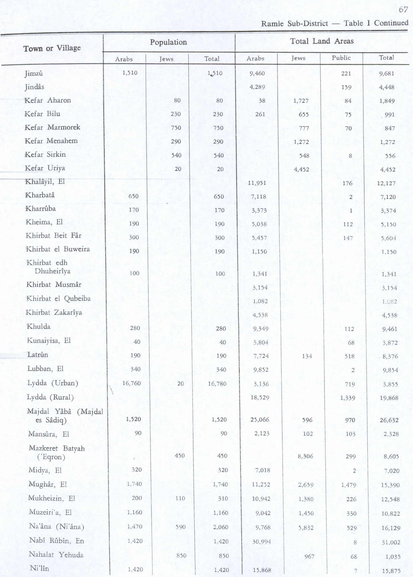
• Total | 300[2][3] |
| Current Localities | Tal Shahar[4][5] |
.jpg)
.jpg)
.jpg)
.jpg)
Khirbat Bayt Far was a Palestinian village in the Ramle Subdistrict of Mandatory Palestine, located 14 km south of Ramla. It was depopulated during the 1947–48 Civil War in Mandatory Palestine on April 7, 1948.
History
Ceramics from the Byzantine era have been found here.[6]
Ottoman era
In 1838, in the late Ottoman era, it was noted as a village in ruins.[7][8]
In 1863 Victor Guérin noted "important ruins" here. "There once stood a hamlet, the ruins of which are scattered over a feeble mound amid the bushes and tall grass."[9]
In 1882, the PEF's Survey of Western Palestine (SWP) found here: "Walls and foundations, apparently modern, with caves and a spring."[10]
British Mandate era
In the 1922 census of Palestine conducted by the British Mandate authorities, Bait Far had a population of 28 Muslims,[11] decreasing in the 1931 census to 26 Muslims, in a total of 11 houses.[12]
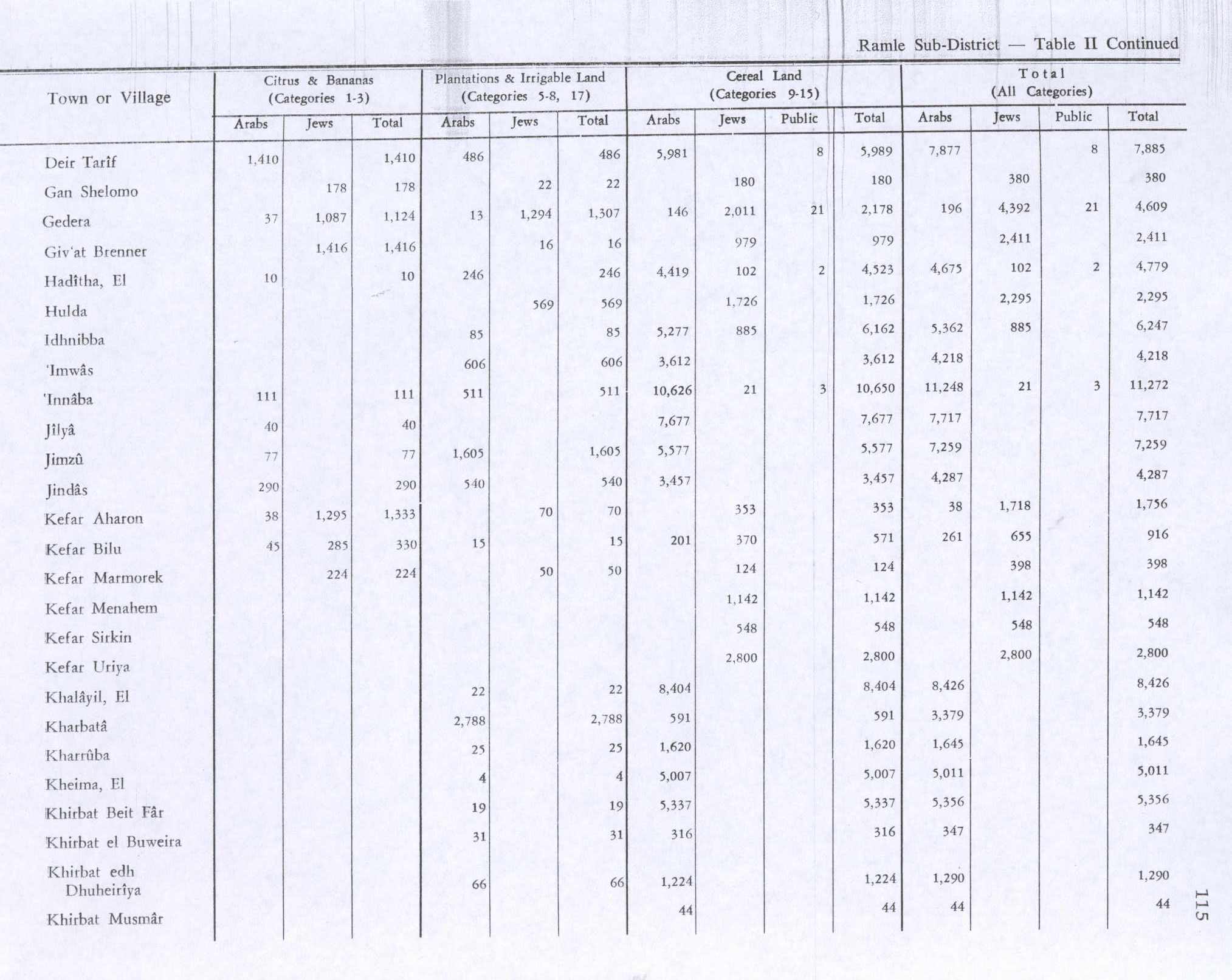
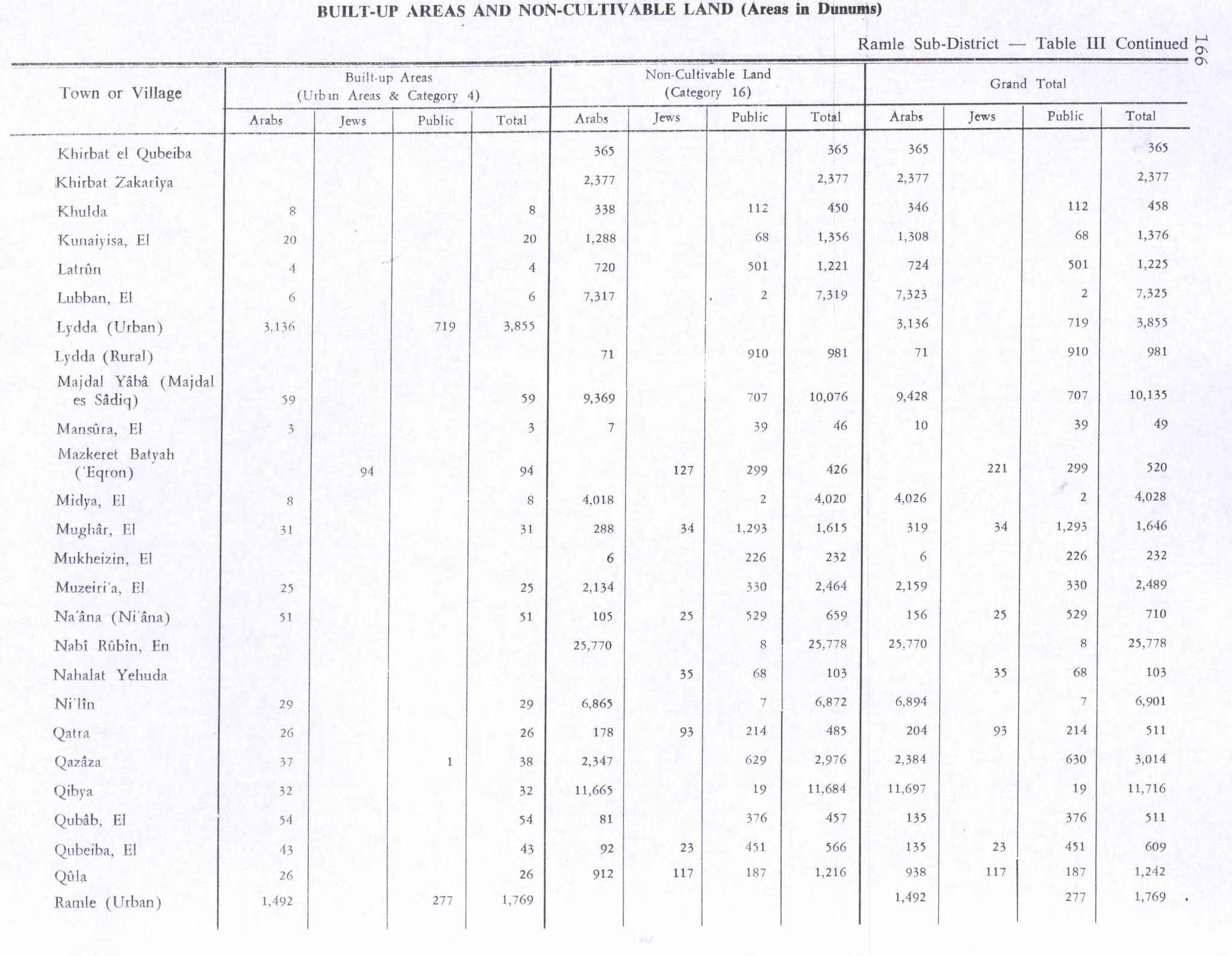
In the 1945 statistics the village had a population of 300 Muslims[2] with a total of 5,604 dunums of land.[3] Of this, 19 dunums were for plantations and irrigable land, 5,337 dunums were for cereals,[13] while a total of 248 dunams were classified as non-cultivable areas.[14]
1948, aftermath
On 11 January 1948, Kfar Uriah was attacked by Arabs who came from neighboring Beit Jiz and Khirbet Beit Far.[15]
In 1948, Beyt Pe'er was founded on village land, it later changed its name into Tal Shahar.[4][16]
In 1992 the village site was described: "All that is left of the village are debris and girders heaped together in a small area. The site is ringed by carob trees. The remains of an uprooted olive grove lies to the north and east."[4]
References
- ↑ Palmer, 1881, p. 269
- ↑ 2.0 2.1 Department of Statistics, 1945, p. 29
- ↑ 3.0 3.1 Government of Palestine, Department of Statistics. Village Statistics, April, 1945. Quoted in Hadawi, 1970, p. 67 Archived 2018-09-06 at the Wayback Machine
- ↑ 4.0 4.1 4.2 Khalidi, 1992, p. 364
- ↑ Morris, 2004, p.xxi, settlement #34, October 1948
- ↑ Dauphin, 1998, p. 900
- ↑ Robinson and Smith, 1841, vol 3, p. 21
- ↑ Robinson and Smith, 1841, vol 3, Appendix 2, p. 120
- ↑ Guérin, 1869, p. 32
- ↑ Conder and Kitchener, 1882, SWP II, p. 237
- ↑ Barron, 1923, Table VII, Sub-district of Ramleh, p. 21
- ↑ Mills, 1932, p. 18.
- ↑ Government of Palestine, Department of Statistics. Village Statistics, April, 1945. Quoted in Hadawi, 1970, p. 115
- ↑ Government of Palestine, Department of Statistics. Village Statistics, April, 1945. Quoted in Hadawi, 1970, p. 165 Archived 2015-09-24 at the Wayback Machine
- ↑ Morris, 2008, p. 102
- ↑ Morris, 2004, p. 380 Morris notes that Tal Shahar was first named Tal-Boqer



Bibliography
- Barron, J. B., ed. (1923). Palestine: Report and General Abstracts of the Census of 1922. Government of Palestine.
- Conder, C.R.; Kitchener, H.H. (1882). The Survey of Western Palestine: Memoirs of the Topography, Orography, Hydrography, and Archaeology. Vol. 2. London: Committee of the Palestine Exploration Fund.
- Dauphin, C. (1998). La Palestine byzantine, Peuplement et Populations. BAR International Series 726 (in français). Vol. III : Catalogue. Oxford: Archeopress. ISBN 0-860549-05-4.
- Department of Statistics (1945). Village Statistics, April, 1945. Government of Palestine.
- Guérin, V. (1869). Description Géographique Historique et Archéologique de la Palestine (in français). Vol. 1: Judee, pt. 2. Paris: L'Imprimerie Nationale.
- Hadawi, S. (1970). Village Statistics of 1945: A Classification of Land and Area ownership in Palestine. Palestine Liberation Organization Research Center. Archived from the original on 2018-12-08. Retrieved 2009-08-18.
- Khalidi, W. (1992). All That Remains:The Palestinian Villages Occupied and Depopulated by Israel in 1948. Washington D.C.: Institute for Palestine Studies. ISBN 0-88728-224-5.
- Mills, E., ed. (1932). Census of Palestine 1931. Population of Villages, Towns and Administrative Areas. Jerusalem: Government of Palestine.
- Morris, B. (2004). The Birth of the Palestinian Refugee Problem Revisited. Cambridge University Press. ISBN 978-0-521-00967-6. (p. 376)
- Morris, B. (2008). 1948: a history of the first Arab-Israeli war. Yale University Press. ISBN 9780300126969. Retrieved 24 July 2013.
- Palmer, E.H. (1881). The Survey of Western Palestine: Arabic and English Name Lists Collected During the Survey by Lieutenants Conder and Kitchener, R. E. Transliterated and Explained by E.H. Palmer. Committee of the Palestine Exploration Fund.
- Robinson, E.; Smith, E. (1841). Biblical Researches in Palestine, Mount Sinai and Arabia Petraea: A Journal of Travels in the year 1838. Vol. 3. Boston: Crocker & Brewster.
External links
- Welcome To Bayt Far, Khirbat, Palestine Remembered
- Khirbat Bayt Far, Zochrot
- Survey of Western Palestine, Map 16: IAA, Wikimedia commons

- Pages using gadget WikiMiniAtlas
- Pages with non-numeric formatnum arguments
- Wikipedia pages with incorrect protection templates
- Coordinates not on Wikidata
- Pages using infobox settlement with deprecated parameters
- CS1 français-language sources (fr)
- Arab villages depopulated during the 1948 Arab–Israeli War
- District of Ramla