

Kluang
Kluang | |
|---|---|
Town and district capital | |
| Kluang Town Bandar Kluang | |
| Motto(s): Maju Sejahtera "Progress, Prosper" (motto of Kluang Municipal Council) | |
| [mapframe not available on SimWiki] Interactive map of Kluang | |
| Coordinates: 2°2′1″N 103°19′10″E / 2.03361°N 103.31944°E | |
| Country | File:Flag of Malaysia.svg Malaysia |
| State | Johor |
| District | Kluang |
| Establishment | 1915 |
| Granted municipal status | 8 May 2001 |
| Government | |
| • Type | Municipal council |
| • Body | Kluang Municipal Council |
| • President | Mohd Fahmy Yahya |
| Area | |
• District | 2,852 km2 (1,101 sq mi) |
| • Urban | 126.57 km2 (48.87 sq mi) |
| Population (2022) | |
• District | 323,762 |
| • Density | 113.5/km2 (294/sq mi) |
| • Urban | 204,964 |
| • Rural | 19,340 |
| Time zone | UTC+8 (MST) |
| • Summer (DST) | UTC+8 (Not observed) |
| Postcode | 86000 |
| Calling code | +60-7 |
| Vehicle registration | J |
| Website | www |

Kluang, formerly spelled Keluang, is a town and the district capital of Kluang District, Johor, Malaysia. Founded in 1915 by the British as the administrative capital for central Johor, Kluang is situated in the central geographical core of the state and lies within a 90-minute drive of major urban hubs across Johor.
Combined with neighboring Batu Pahat, central Johor encompasses a total market catchment exceeding 700,000 residents. Throughout the 20th century, Kluang's agricultural economy transitioned from natural rubber cultivation to large-scale palm oil production. In recent decades, it has developed a major organic farming sector alongside ecotourism destinations such as Zenxin Organic Park, UK Agro Farm, and Kahang Organic Eco Rice Farm. The district also houses a significant industrial base, particularly in ceramic tile manufacturing, earning it a reputation as the "tile capital of Malaysia".
History
The name Kluang originates from the Malay word keluang, referring to a species of flying fox or fruit bat that was historically abundant in the region prior to widespread deforestation and habitat loss.
Kluang was established in 1915 as the administrative hub for central Johor under British colonial rule.[1] The construction of the main Malayan Railway line passing through the town accelerated its early urban and economic growth, which was further supported by road links connecting Kluang south-eastward to Johor Bahru, south-westward to Batu Pahat, and north-eastward to Mersing.
During World War II, Imperial Japanese forces occupied Kluang on 25 January 1942 during their swift advance southwards following the retreat of Allied troops toward Singapore. General Tomoyuki Yamashita relocated his forward headquarters from Kuala Lumpur to Kluang on 27 January 1942. The Japanese military subsequently operated the local airfield as an airbase for bombing strikes targeting Singapore and Sumatra.
In the mid-1950s, during the Malayan Emergency, the airfield served as a base for reconnaissance aircraft and military helicopters tracking communist insurgents operating in the Gunung Lambak area, as well as an artillery base. The airfield hosted the Kluang Flying Club, which operated Tiger Moth biplanes. Insurgent activity around Kluang largely subsided in the months leading to Malayan Independence in 1957. The surrounding area was developed into a major military garrison hosting various units and a field hospital. The 75 Aircraft Workshop, an aviation support unit, was based in Kluang from 1946 until 1970.[2]
In 1969, Kluang experienced a major disaster when the Mengkibol River overflowed by 7 to 10 ft (2.1 to 3.0 m), causing extensive property damage throughout the town center.[3]
Today, the Malaysian Army maintains a significant presence in Kluang at Kem Batu Tiga and Kem Mahkota, the latter housing the Malaysian Army Aviation unit (881 Squadron).
Geography
Kluang is situated in central Johor and is entirely landlocked. The town lies in a terrain of undulating hills; its most prominent geographical landmark is Gunung Lambak, an isolated peak standing at 510 metres (1,670 ft) above sea level situated on the eastern outskirts of the town. In the eastern segment of the district lies the Gunung Belumut Recreational Forest.
The administrative area governed by the Kluang Municipal Council covers approximately 126.57 km2 (48.87 sq mi).[4] Three main watercourses flow through the town area: the Mengkibol River bisects the town center, while the Melantai River runs through the eastern sector and the Sembrong River flows across the west.
Urban expansion from the 1970s through the 2000s saw Kluang grow horizontally along major east-west arterial corridors. Over this period, the commercial core expanded significantly as former rubber and oil palm agricultural land was redeveloped into residential subdivisions and commercial precincts.
Demographics
In 2010, the population of Kluang District stood at 319,629 residents.[5]
By 2022, the district population reached 323,762 people out of four million statewide, with males accounting for 55.4% of the population.[6]
Government and politics
Kluang Municipal Council Majlis Perbandaran Kluang | |
|---|---|
| Coat of arms or logo Emblem | |
| Type | |
| Type | Local authority of Kluang |
| History | |
| Founded | 8 May 2001 |
| Preceded by | Kluang North District Council |
| Leadership | |
President | Mohd Fahmy Yahya (Since 20 October 2024) |
Secretary | Azmi Ahmad (Since 1 January 2024) |
| Structure | |
| Seats | 24 |
Political groups | Councillors: |
Length of term | 1 April 2024–31 December 2025 |
| Motto | |
| Maju Sejahtera (Progress, Prosper) | |
| Meeting place | |
| Wisma Baharu Majlis Perbandaran Kluang, Persiaran Utama Bandar Primer, 86000 Kluang, Johor | |
| Website | |
| www | |

The Kluang Municipal Council (Malay: Majlis Perbandaran Kluang, MPKluang), formerly known as the Kluang North District Council (Malay: Majlis Daerah Kluang Utara), is the local government body administering Kluang town and surrounding areas. It was elevated to municipal council status on 8 May 2001. The former North District Council was created on 1 January 1977 through the merger of the Kluang Town Council (originally established as the Kluang Town Board in 1920) with local councils governing Kampong Paya, Kampong Gajah, Sri Lalang, Chamek, and Paloh.[7] The council headquarters relocated to Wisma Baharu MPKluang on Persiaran Utama Bandar Primer on 1 July 2025, moving from its long-time facility at Jalan Kota Tinggi.[8]
Presidents of Kluang
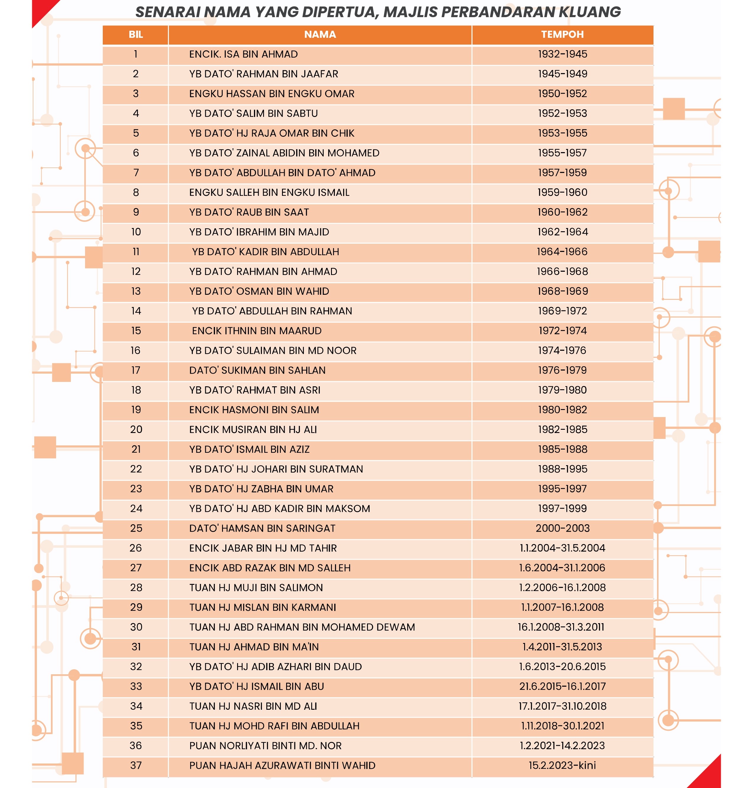
Thirty-eight individuals have served as president of the local authority since 1932.[9]
| # | Name | Term start | Term end |
|---|---|---|---|
| 1 | Isa Ahmad | 1932 | 1945 |
| 2 | Rahman Jaafar | 1945 | 1949 |
| 3 | Hassan Omar | 1950 | 1952 |
| 4 | Salim Sabtu | 1952 | 1953 |
| 5 | Raja Omar Chik | 1953 | 1955 |
| 6 | Zainal Abidin Mohamed | 1955 | 1957 |
| 7 | Abdullah Ahmad | 1957 | 1959 |
| 8 | Salleh Ismail | 1959 | 1960 |
| 9 | Raub Saat | 1960 | 1962 |
| 10 | Ibrahim Majid | 1962 | 1964 |
| 11 | Kadir Abdullah | 1964 | 1966 |
| 12 | Rahman Ahmad | 1966 | 1968 |
| 13 | Osman Wahid | 1968 | 1969 |
| 14 | Abdullah Rahman | 1969 | 1972 |
| 15 | Ithnin Maarud | 1972 | 1974 |
| 16 | Sulaiman Md Noor | 1974 | 1976 |
| 17 | Sukiman Sahlan | 1976 | 1979 |
| 18 | Rahmat Asri | 1979 | 1980 |
| 19 | Hasmoni Salim | 1980 | 1982 |
| 20 | Musiran Ali | 1982 | 1985 |
| 21 | Ismail Aziz | 1985 | 1988 |
| 22 | Johari Suratman | 1988 | 1995 |
| 23 | Zabha Umar | 1995 | 1997 |
| 24 | Abd Kadir Maksom | 1997 | 1999 |
| 25 | Hamsan Saringat | 2000 | 2003 |
| 26 | Jabar Md Tahir | 1 January 2004 | 31 May 2004 |
| 27 | Abd Razak Md Salleh | 1 June 2004 | 31 January 2006 |
| 28 | Muji Salimon | 1 February 2006 | 31 December 2006 |
| 29 | Mislan Karmani | 1 January 2007 | 16 January 2008 |
| 30 | Abd Rahman Mohamed Dewam | 16 January 2008 | 31 March 2011 |
| 31 | Ahmad Ma'in | 1 April 2011 | 31 May 2013 |
| 32 | Adib Azhari Daud | 1 June 2013 | 20 June 2015 |
| 33 | Ismail Abu | 21 June 2015 | 16 January 2017 |
| 34 | Nasri Md Ali | 17 January 2017 | 31 October 2018 |
| 35 | Mohd Rafi Abdullah | 1 November 2018 | 30 January 2021 |
| 36 | Norliyati Md Nor | 1 February 2021 | 14 February 2023 |
| 37 | Azurawati Wahid | 15 February 2023 | 19 October 2024 |
| 38 | Mohd Fahmi Yahya | 20 October 2024 | Present |
Secretaries of Kluang
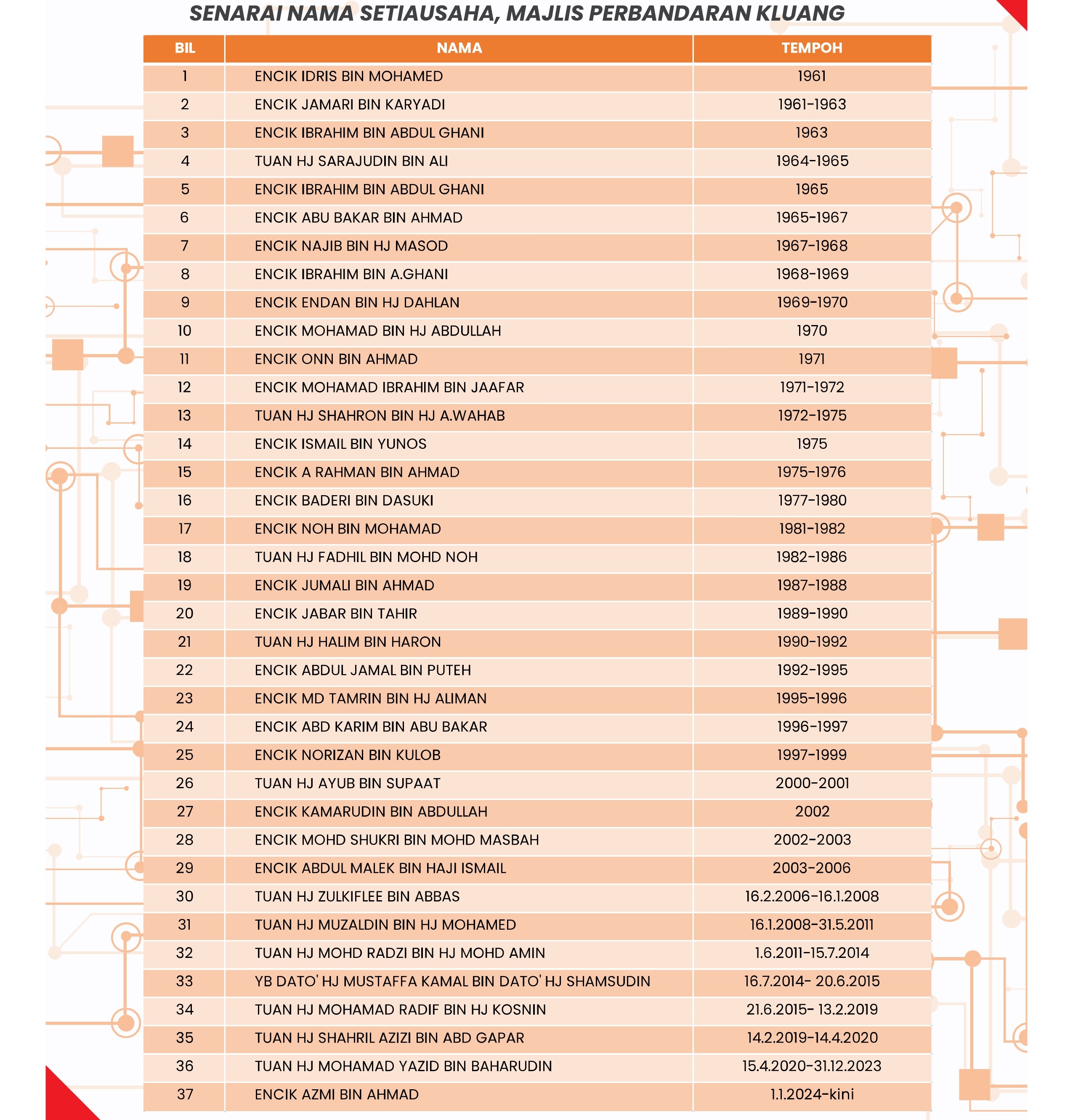
Thirty-seven individuals have served as council secretary.[10]
| # | Name | Term start | Term end |
|---|---|---|---|
| 1 | Idris Mohamed | 1961 | 1961 |
| 2 | Jamari Karyadi | 1961 | 1963 |
| 3 | Ibrahim Abdul Ghani | 1963 | 1963 |
| 4 | Sarajudin Ali | 1964 | 1965 |
| 5 | Ibrahim Abdul Ghani | 1965 | 1965 |
| 6 | Abu Bakar Ahmad | 1965 | 1967 |
| 7 | Najib Masod | 1967 | 1968 |
| 8 | Ibrahim Abdul Ghani | 1968 | 1969 |
| 9 | Endan Dahlan | 1969 | 1970 |
| 10 | Mohamad Abdullah | 1970 | 1970 |
| 11 | Onn Ahmad | 1971 | 1971 |
| 12 | Mohamad Ibrahim Jaafar | 1971 | 1972 |
| 13 | Shahron Abdul Wahab | 1972 | 1975 |
| 14 | Ismail Yunos | 1975 | 1975 |
| 15 | Abdul Rahman Ahmad | 1975 | 1976 |
| 16 | Baderi Dasuki | 1977 | 1980 |
| 17 | Noh Mohamad | 1981 | 1982 |
| 18 | Fadhil Mohd Noh | 1982 | 1986 |
| 19 | Jumali Ahmad | 1987 | 1988 |
| 20 | Jabar Tahir | 1989 | 1990 |
| 21 | Halim Haron | 1990 | 1992 |
| 22 | Abdul Jamal Puteh | 1992 | 1995 |
| 23 | Md Tamrin Aliman | 1995 | 1996 |
| 24 | Abd Karim Abu Bakar | 1996 | 1997 |
| 25 | Norizan Kulob | 1997 | 1999 |
| 26 | Ayub Supaat | 2000 | 2001 |
| 27 | Kamarudin Abdullah | 2002 | 2002 |
| 28 | Mohd Shukri Mohd Masbah | 2002 | 2003 |
| 29 | Abdul Malek Ismail | 2003 | 2006 |
| 30 | Zulkiflee Abbas | 16 February 2006 | 16 January 2008 |
| 31 | Mulzaldin Mohamed | 16 January 2008 | 31 May 2011 |
| 32 | Mohd Radzi Mohd Amin | 1 June 2011 | 15 July 2014 |
| 33 | Mustaffa Kamal Shamsudin | 16 July 2014 | 20 June 2015 |
| 34 | Mohamad Radif Kosnin | 21 June 2015 | 13 February 2019 |
| 35 | Shahril Azizi Abd Gapar | 14 February 2019 | 14 April 2020 |
| 36 | Mohamad Yazid Baharudin | 15 April 2020 | 31 December 2023 |
| 37 | Azmi Ahmad | 1 January 2024 | Present |
Municipal Administration Zones
For local administration, the municipality is divided into 24 administrative zones, each represented by an appointed local councillor.[11][12]
| Zone | Councillor | Political affiliation |
|---|---|---|
| Kahang A | Abdul Ghani Abdul Rashid | UMNO |
| Paloh A | Atan Ibrahim | UMNO |
| Paloh B | Au Xian Jie | MCA |
| Sri Lalang | Gan Lee Chiu | MCA |
| Kampong Melayu | Haslina Mohammad Dom | UMNO |
| Kampong Paya | Kelly Chye Pei Yee | MCA |
| Taman Intan | Izaluddin Akmat | UMNO |
| Town Centre (Bandar) | Law Mona | MCA |
| Taman Puteri | Mohd Saim Paiman | UMNO |
| Taman Suria | Law Yew Shen | MCA |
| Taman Megah | Raman M Govindan Nair | MIC |
| Sri Kluang | Mohd Khairul Ishak | UMNO |
| Kahang B | Siti Norreha Hussin | UMNO |
| Taman Delima | S Sarasvathi K.Sinatambi | MIC |
| Taman Kasih | Zainal Mohamed | UMNO |
| Taman Sri Tengah | Zakiah Pardi | UMNO |
| Taman Pelangi | Zaimani Jamaluddin | UMNO |
| Yap Tau Sah | Yap Zhi Peng | MCA |
| Taman Kluang Barat | Azizul Ali | UMNO |
| Taman Ilham | Abd Hamid Dahlan | UMNO |
| Chamek | Go Yen Hong | MCA |
| Gunung Lambak | Shey Risha Abdul Karim | UMNO |
| Kampung Gajah | Lim Yew Chin | MCA |
| Taman Seri Impian | Syed Hussin Syed Abdullah | UMNO |
Agriculture
Following its founding in 1915, Kluang developed predominantly as a center for rubber cultivation under major plantation companies including Guthrie Ropel, Asiatic Plantations, and Harrisons & Crosfield. Industrial innovations, such as the vacuum evaporation of latex developed by Revertex, were introduced locally. Notable rubber plantations surrounding the town included Lambak Estate, Mengkibol Estate, Kluang Estate, Coronation Estate, Wessington Estate (renamed Simpang Renggam Estate), Benut Estate, Paloh Estate, Sepuloh Estate, Chamek Estate, Niyor Estate, Kahang Estate, Pamol Estate, and Kekayaan Estate.
Starting in the 1970s, rubber estates were systematically replanted with oil palms. Today, Kluang houses extensive oil palm holdings, as well as cocoa and tea cultivation. Pamol Estate, owned by IOI Corporation, is an active producer with 12,044 hectares (29,760 acres) of certified sustainable palm oil plantations producing over 56,000 tonnes annually.[13]
The district also developed an organic farming industry. The 100-acre Zenxin Agri-Organic Food farm is among the largest organic vegetable producers in Malaysia.[14] The Kluang Modern Agriculture Project (Projek Pertanian Moden Kluang), launched in 2004 across 9,000 acres, houses livestock and herbal farms including UK Agro Farm.[15] In Kahang, the Kahang Organic Eco Rice Farm operates as Malaysia's first certified organic rice paddy enterprise.
Industry and commerce
Kluang maintains a diverse industrial manufacturing sector alongside its agricultural base, producing polymers, paper products, textiles, ceramics, industrial coatings, and electrical goods.
The town is a manufacturing center for ceramic tiles. Companies such as MML (Malaysian Mosaics), Terreal, Venus Ceramic, and Guocera operate major industrial facilities in Kluang, contributing to Malaysia's global tile production.
Multinational manufacturing facilities in the district include Kimberly-Clark's tissue paper manufacturing plant and Liebherr Group's refrigeration unit production plant. Synthomer plc operates a major nitrile latex manufacturing complex in Kluang, inheriting facilities originally established by Revertex Ltd. The facility produces nitrile latex utilized in the global medical glove manufacturing industry.
The downtown commercial district lies within the Kluang Inner Ring Road and hosts major commercial banks, retail complexes, and services.
Transport
Road
Kluang is accessible via Exit 244 (Ayer Hitam) on the PLUS Expressway. Federal Route 50 connects Batu Pahat through downtown Kluang eastward toward Kahang, Jemaluang, and Mersing.
Rail
Keretapi Tanah Melayu (KTMB) serves the Kluang railway station located along Jalan Stesen. Under the Gemas–Johor Bahru electrified double-tracking project, rail infrastructure through Kluang is integrated into the electrified intercity network connecting to Kuala Lumpur, Johor Bahru, and Butterworth.
Bus
The Kluang express bus terminal is located on Jalan Bakawali next to Plaza BCB. Express intercity buses connect Kluang to major urban centers in Peninsular Malaysia and Singapore.
Air
A military airfield ((ICAO: WMAP)) operated by the Royal Malaysian Air Force is situated in Kluang. The nearest commercial facility is Senai International Airport (IATA: JHB) in Kulai District, situated approximately 90 km (56 mi) south.
Infrastructure
Kluang is served by a district police station and a fire station.
Kluang Hospital is managed by the Ministry of Health and located in the southern part of the town. There also a KPJ Kluang Utama Specialist Hospital.
Education
Sekolah Menengah Sains Johor (SMS Johor), was the first government boarding secondary school with a special emphasis on science subjects. It was founded in 1973 and currently has over 500 students.
Kluang High School or Sekolah Tinggi Kluang is one of the best known schools in Kluang and was founded in 1939. It now has over 1,500 students.[16]
The Chong Hwa High School is the third biggest Chinese secondary school[17] in Malaysia and was financially established by reputable Chinese settlers in the 1940s.[18] The school enrolls over 3,000 students.
Culture and tourism
Kluang is a center for agritourism and nature recreation. Hiking trails on Gunung Lambak and Gunung Belumut are popular local destinations.
The town is also noted for its regional coffee culture, represented by Kluang RailCoffee at the main railway station, which has operated since 1938.
Sister cities
- Malaysia Selangor Kajang, Selangor, Malaysia[citation needed]
- Malaysia Perak Taiping, Perak, Malaysia[citation needed]


Notable people
- Samy Vellu, President of Malaysian Indian Congress (MIC)(1979–2010), Minister of Works (1995–2008)
- Ali Hamsa, Chief Secretary to the Government
- Chieh Yuan (1945–1977), Actor and martial artist
- Lee San Choon, President of Malaysian Chinese Association (MCA)(1975–1983)
- Ng Tian Hann, Malaysia Chinese Movie Director
- Shebby Singh, Malaysian former footballer
- Nur Izzuddin, badminton player
- Noraniza Idris, singer and actress
- Bishop Dato' Charles K. Samuel, Suffragan Bishop of the Anglican Church of West Malaysia
See also
References
- ↑ "History of Kluang". Bernama. Archived from the original on 8 July 2003. Retrieved 8 July 2003.
- ↑ "75 Aircraft Workshop Kluang" (PDF). Helicraft. Retrieved 21 May 2023.
- ↑ "Gurudwara Sahib Kluang, Johor". World Gurudwaras. Archived from the original on 28 October 2020. Retrieved 3 December 2020.
- ↑ jhrmpk (8 May 2016). "History Kluang". Official Portal of Kluang Municipal Council (MPK) (in Bahasa Melayu). Retrieved 8 December 2023.
- ↑ "Handbook" (PDF). johor.gov.my (in Bahasa Melayu). Archived from the original (PDF) on 13 September 2018. Retrieved 20 May 2023.
- ↑ "Kluang placed fourth in state's population census". The Star. Retrieved 8 December 2023.
- ↑ "Background". mpkluang.gov.my.
- ↑ "Headquarters Directory". mpkluang.gov.my.
- ↑ "List of Presidents". mpkluang.gov.my.
- ↑ "List of Secretaries". mpkluang.gov.my.
- ↑ "Councillor list". mpkluang.gov.my.
- ↑ "Councillor list (PDF)" (PDF). mpkluang.gov.my.
- ↑ IOI Corporation Berhad. TA Securities. 28 March 2016. p. 2. Archived from the original on 20 April 2016. Retrieved 11 July 2017.
- ↑ "About Zenxin". Zenxin Organic. Archived from the original on 15 March 2016.
- ↑ "UK Agro Resort". UK Farm. Archived from the original on 30 June 2017. Retrieved 11 July 2017.
- ↑ "SMS Johor". Retrieved 21 May 2023.
- ↑ "銮中 KLUANG CHONG HWA HIGH SCHOOL". Retrieved 21 May 2023.
- ↑ Turnbull, A Short History of Malaysia, Singapore and Brunei, p. 124
External links

- Pages using gadget WikiMiniAtlas
- CS1 Bahasa Melayu-language sources (ms)
- Use Indian English from March 2015
- All Wikipedia articles written in Indian English
- Use dmy dates from March 2015
- Pages using infobox settlement with possible motto list
- Coordinates not on Wikidata
- Pages using infobox settlement with no map
- Pages using infobox settlement with deprecated parameters
- Articles containing Malay (macrolanguage)-language text
- Articles with unsourced statements from July 2017
- Kluang District
- Towns in Johor